Dstl develops new Space weather sensing suite
The Coordinated Ionospheric Reconstruction Cubesat Experiment (CIRCE) comprises two 6U cube-satellites that will be launched into a near-polar low earth orbit (500km altitude) this year. Each 6U satellite bus, measures 10cm x 20cm x 30cm, and will fly almost identical instrument capability on both satellites.

The UK contribution to CIRCE is the Insitu and Remote Ionospheric Sensing (IRIS) suite, complementary to NRL sensors and comprising three highly miniaturised payloads developed for Dstl by University College London (UCL), University of Bath and University of Surrey/Surrey Satellite Technology Ltd (SSTL). CIRCE will characterise a region of the Space environment, the ionosphere, which is important for a range of defence and civil applications and can impact GPS, communications and sensing technology.
All three IRIS payloads occupy a small volume no more than 10 cm x 10cm x 20 cm – you can hold IRIS in one hand. Miniaturisation of Space weather sensors means that a significant capability is packed into each satellite provided by Blue Canyon Technologies. This type of miniaturisation could pave the way for deployment of many more such sensors as a routine inclusion on other satellites thanks to their small size, weight and power. The result would expand data collection for the near-Earth Space environment, and enhance space weather modelling capabilities.
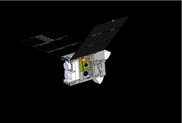
Above:
CAD models of the CIRCE mission satellite buses
Courtesy Blue Canyon Technologies
Dr Nick Joad, Director Defence Science and Technology, said: “The CIRCE mission is great example of UK/US collaboration in Space. The concept to develop UK Space weather diagnostic capability supports our strategic relationship with the USA, and Dstl has recently delivered two flight models - totalling six miniaturised UK payloads – in just one year.
"Our UK partners from academia and industry are recognised world-leaders in the field of Space weather research, enabling us to rapidly design, build, and successfully test these tiny payloads.”
CIRCE is the flagship mission of the UK-US Science and Technology Joint Communique, where the aim is to build on our existing strong relationship in this area to address emerging priorities through joint research on various themes, including space weather.
IRIS provides in-situ ionospheric particle & radiation measurements (INMS and RadMon), combined with remote-sensing of triple-frequency GPS signals to map the topside ionosphere and beyond (TOPCAT). The UK data will provide contextual environmental information for CIRCE and enrich the science that can be derived from NRL’s triple tiny ionospheric photometry (Tri-TIP) ultra violet optics cameras, for tomographic specification of electron density.
The IRIS suite, integrated by SSTL, includes:
- An Ion and Neutral Mass Spectrometer (INMS), developed by UCL’s Mullard Space Science Laboratory, which will improve understanding of the variability of atmospheric drag, the chemistry of the thermosphere and the impact of space weather on the upper-atmosphere;
- A Radiation Monitor (RadMon) from SSTL will identify areas of increased radiation for satellites to avoid, help identify suitable orbits and shielding requirements for future satellites, and highlight dynamic radiation enhancements that can be cross-correlated with payload and subsystem anomalies;
- A remote sensor called TOPCAT, developed by Bath University’s department of Electronic and Electrical Engineering, will look at remote sensing of triple-frequency GPS signals, and validate the UK’s Multi-Instrument Data Analysis System (MIDAS) tomography algorithm for the topside ionosphere and plasmasphere, by using total electron content (TEC) measurements from the differential phase of GPS signals, inverting them to derive the electron density of the region.