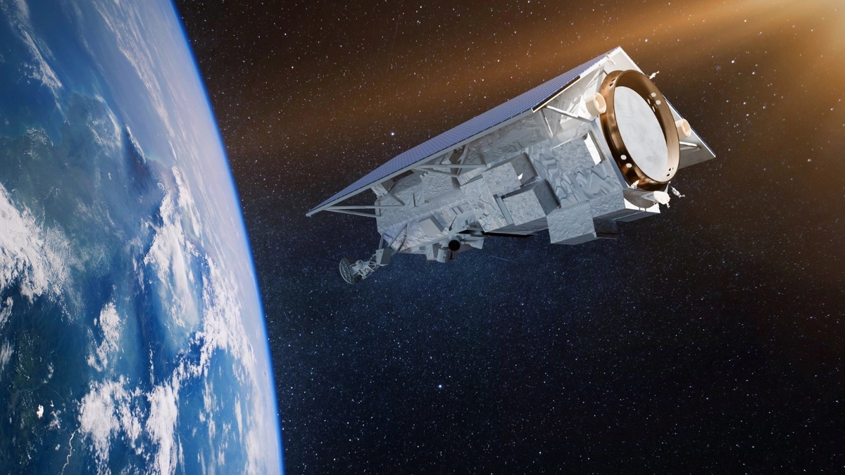
Sentinel-1C launched into orbit
Image courtesy UKSA
A new radar satellite - Sentinel-1C - supported by the UK, was launched into space from French Guiana at 9:20pm GMT on Thursday 5th December.
The Sentinel-1C satellite launched on a VEGA-C rocket and will orbit 700km above the Earth’s surface. Part of Europe’s Copernicus programme, it will use advanced radar technology to provide continuous imaging over land and sea, day and night, and even through cloud cover.

Science Minister Lord Vallance said: "The successful launch of this new satellite will further strengthen the Copernicus programme, which continues to collect vital long-term data allowing us to better understand our planet, respond to natural disasters and tackle global challenges like climate change."
The UK’s Earth Observation industry is integral to the Sentinel 1 satellites, with the support of the UK Space Agency.
Airbus Defence and Space (Portsmouth) developed the electronics subsystem of the key Synthetic Aperture Radar (SAR) instrument aboard the satellite. Honeywell UK was responsible for the receiver of the Automated Identification System (AIS) payload, which will be key for maritime surveillance capabilities. Additionally, the battery for Sentinel-1C was supplied by Enersys ABSL (Abingdon).
Justin Byrne, Head of Earth Observation and Science at Airbus Defence and Space UK, said: "Airbus in the UK has designed and manufactured the entire family of radar electronic subsystems for the Sentinel 1 satellites; this continues the UK provision of key instrument elements for all European Space Agency and European Union SAR satellites in orbit."
Once it reaches its intended orbit, Sentinel-1C will synchronise with Sentinel-1A which is already in space. These satellites will work in partnership with each other to deliver the Sentinel-1 mission, imaging the Earth and generating large amounts of data that is fed into the various services provided by Copernicus.
Dr Chandra Taposeea-Fisher, Chair of EO Committee, UKspace trade association, said: "The SAR instruments on the Sentinel-1 satellites have contributed greatly to the monitoring of Arctic sea-ice extent, routine sea-ice mapping, marine environment surveillance, land-surface motion risks, forest, water & soil management, as well as contributing to humanitarian aid and crisis situations.
"Data from the Sentinel-1 satellites has been used throughout the UK EO Community, by government, industry and academia. We welcome the successful launch of Sentinel-1C, opening a new chapter in the EO world."
Unlike research satellites, Sentinel-1C imagery is designed to sustain a reliable operational service, with consistent and long-term data collection for key applications. This is crucial for land and maritime monitoring, tracking of sea ice, emergency response to flooding and earthquake events, tracking climate variables and assessing the impacts of climate change.
Professor Gideon Henderson, Chief Scientific Adviser for Defra, said: "Copernicus was a catalyst to the widespread uptake and use of Earth Observation to aid evidence-based policy delivery, monitoring and enforcement activities.
"The launch of Sentinel-1C will continue to support the National Forestry Inventory; flood response mapping and detecting illegal fishing.
"We are also researching how Interferometric SAR techniques can show ground deformation in peat bogs caused by fluctuations in water storage, sometimes known as bog breathing. This will help us better understand peat-bog health and carbon storage potential."
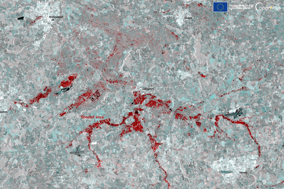
Above: This Sentinel-1 image acquired on 24th November 2024 shows the flooded areas near the towns of Langport, Bridgwater and Yeovil in red tones. The Copernicus Sentinel satellites deliver key data for monitoring and delineating the extent of areas affected by floods, supporting local decision-making during emergencies.
Credit: European Union, Copernicus Sentinel-1 imagery
Prof John Remedios, Director of the National Centre for Earth Observation said: "The advent of operational radar satellites has been a huge boost to our ability to observe hazardous and extreme environments, for example where people are vulnerable to earthquakes and volcanoes.
"Sentinel-1C will renew the extensive coverage and clever products which result from combining data from two radar satellites operating at the same time, allowing scientists and businesses to measure ground motion from glaciers to cities."
As well as its radar instrument, Sentinel-1C will also carry a new Automatic Identification System (AIS), developed by the International Maritime Organisation to help ships avoid collisions at sea. The combination of radar images and AIS signals improves the monitoring of global shipping traffic and can also help detect piracy and other illegal activities.
This latest milestone for Copernicus follows the successful launch of another satellite - Sentinel-2C - in September this year. This satellite is already providing high-resolution imagery and data – it is a powerful tool that enhances the UK and Europe’s capabilities in monitoring land and vegetation.