Flare Bright capabilities underpinned by DASA support

Courtesy DASA
Using its software-enhanced Inertial Navigation System (INS), Flare Bright aims to solve the problem of what happens if GPS is denied during drone operations.
After successful initial DASA funding in 2021, to prove the concept of true autonomy in drones, Flare Bright was awarded a larger follow-up contract to provide the same autonomy in powered drones to give increased persistence and endurance. This project delivered a fixed-wing drone able to fly without GPS or any remote-control while being immune to jamming. A third DASA contract was absorbed into a Defence Science Technology Laboratory (Dstl) programme.
Since then, Flare Bright has shifted its focus from developing the drones, to developing advanced software that can be used in other companies’ existing and future drones, both aerial and undersea. Flare Bright has now established a thriving defence business.
Showcasing success
As well as early stage funding and business support, DASA invited Flare Bright to exhibit on its stand at the international defence and security exhibition DSEI 2021, an opportunity to showcase its advanced project to a global audience of international governments, armed forces and industry leaders. Flare Bright was back at this year’s DSEI 2023, in September with its own stand.

Digital twin software
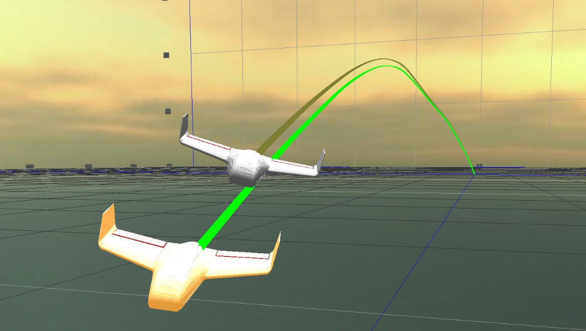
Key to Flare Bright’s offering is its use of software modelling to create a ‘digital twin’ of an unmanned aircraft, or drone. The software model takes into account multiple variables including the drone’s aerodynamics, propulsion and fuel use to create a digital twin of the real aircraft. It then applies machine learning algorithms in a digital twin environment to solve sensing, navigation, control and optimisation problems.
The digital twin software, with its extremely accurate representations of all the aircraft’s performance data and parameters, is then uploaded into the real drone, which uses its own sensors to measure wind and other factors as it flies.
As a result, if GPS fails, or is denied by an adversary, the drone is able continuously to measure where it is by sensing speed and external conditions, taking into account its internal software model. This gives it a constant, highly accurate internal navigation ‘fix’ on its location.
As it does not require visual information it cannot be spoofed by an adversary, as happens regularly to drones in the Ukraine conflict.
Chris Daniels, Chief Commercial Officer of Flare Bright, explained that the company models the drone by breaking it down into many small digital pieces to create a physics model - a mathematical description of a system used to make testable predictions about its behaviour: "Whatever data is produced internally we can measure and compare to the physics model, so that it flies as close as possible to reality.
"When we put the software in the aircraft, it knows how fast it is flying over the ground and other parameters so that it can fix its position accurately."
Flare Bright’s process of analysing flight data is much cheaper to achieve the same results than conducting physical tests and it can also be used for other purposes. Chris said: “As well as flying accurately in GPS-denied areas, it enables unique capabilities for drones such as, in-flight wind sensing, regulatory and safety case assurance and for test and evaluation purposes.”
Flare Bright is currently engaged on its fourth sprint project with the US DoD, conducting trials of its technology in Spain, over water (so no visual navigation) and without GPS. It also has contracts with Dstl and the MoD.
Chris said that DASA’s initial funding was important to help Flare Bright’s innovation at an early stage, as non-equity money it was critical and working with DASA also opened doors to other organisations such as Dstl: “At our DASA end-of-contract demo day, there was a lot of interest in us from other organisations."
Thanks to that initial DASA funding, Flare Bright continues to look up. The company’s future involves adapting its expertise in fixed wing UAVs to other aircraft, rockets and projectiles. GPS denial in the air is becoming more prevalent due to deliberate action from adversaries, from solar weather and also difficult conditions on the ground, especially in urban areas. This solution to GPS-denied activity is a key part of the Generation After Next Alternative-Navigation sector.
Yet it is not just in the aviation sector where Flare Bright is flying high. The company has also been asked to use its machine learning digital twin expertise in both the maritime and subsea sector and for other optimisation tasks for a wide range of technologies.
Fast-forwarding on from its original success to now, Flare Bright is continuing to thrive and push the boundaries on what is capable with its Machine Learning Digital-Twin, where it is building on the foundations originally laid back in 2021 and further expanding its capabilities.
This provides key cutting-edge performance enhancements for the platforms on which this system has been implemented, giving the systems a crucial advantage in the majority of scenarios they will find themselves in.
Additionally, Flare Bright has found customers wanting to use its Machine Learning Digital Twin software for GPS-Free Navigation, Reduced real world testing, Optimised Test & Evaluation, Safety Trace and Accelerated Research and Development.
DASA Case Study: Courtesy DASA


