Drone mapping reveals Caucasus' mega fortress secrets

Image courtesy Cranfield University
Dr Nathaniel Erb-Satullo (above), Senior Lecturer in Architectural Science at Cranfield Forensic Institute, has been researching the site since 2018 with Dimitri Jachvliani, his co-director from the Georgian National Museum, revealing details that re-shape our understanding of the site and contribute to a global reassessment of ancient settlement growth and urbanism.

Fortress settlements in the South Caucasus appeared between 1,500-500 BCE and represent an unprecedented development in the prehistory of the regions. Situated at the boundary between Europe, the Eurasian Steppe and the Middle East, the Caucasus region has a long history as a cultural crossroads with distinctive local identities.
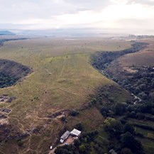
Research on the fortress – named Dmanisis Gora – began with test excavations on a fortified promontory between two deep gorges. A subsequent visit in Autumn, when the knee-high high summer grasses had died back, revealed that the site was much larger than originally thought. Scattered across a huge area outside the inner fortress were the remains of additional fortification walls and other stone structures. Because of its size, it was impossible to get a sense of the site as a whole from the ground.
Using an eye in the sky
“That was what sparked the idea of using a drone to assess the site from the air,” commented Dr Erb-Satullo. “The drone took nearly 11,000 pictures which were knitted together using advanced software to produce high-resolution digital elevation models and orthophotos – composite pictures that show every point as if you were looking straight down.
“These datasets enabled us to identify subtle topographic features and create accurate maps of all the fortification walls, graves, field systems and other stone structures within the outer settlement. The results of this survey showed that the site was more than 40 times larger than originally thought, including a large outer settlement defended by a 1km long fortification wall.”
The research team used a DJI Phantom 4 RTK drone which can provide relative positional accuracy of under two centimetres as well as extremely high-resolution aerial imagery. In order to obtain a highly accurate map of human-made features, the team carefully checked each feature in the aerial imagery to confirm its identification.
To understand how the landscape of the site had evolved, the orthophotos were compared with 50-year-old photos taken by a Cold War-era spy satellite declassified in 2013. That gave researchers much needed insight into which features were recent, which were older. It also enabled researchers to assess what areas of the ancient settlement were damaged by modern agriculture. All of those data sets were merged in Geographic Information System (GIS) software, helping to identify patterns and changes in the landscape.
“The use of drones has allowed us to understand the significance of the site and document it in a way that simply wouldn’t be possible on the ground” said Dr Erb-Satullo. ”Dmanisis Gora isn’t just a significant find for the Southern Caucasus region, but has a broader significance for the diversity in the structure of large scale settlements and their formation processes. We hypothesise that Dmanisis Gora expanded because of its interactions with mobile pastoral groups and its large outer settlement may have expanded and contracted seasonally. With the site now extensively mapped, further study will start to provide insights into areas such as population density and intensity, livestock movements and agricultural practices, among others.”
This data will give researchers new insights into Late Bronze Age and Early Iron Age societies and how these communities functioned. Since the aerial survey was completed, Dr Erb-Satullo has been carrying out further excavations at the site, uncovering tens of thousands of pottery shards, animal bones and other artefacts that tell us more about the society that built this fortress.
This work has been funded by the Gerda Henkel Foundation, the Gerald Averay Wainwright Fund and the British Institute at Ankara.