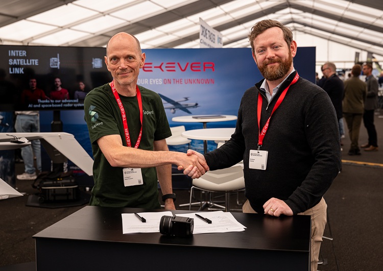
SSTL signs with Satellite Vu for MWIR

Above:
SatelliteVu's MWIR Pathfinder will be based on SSTL's DarkCarb satellite.
Courtesy SSTL
The constellation will have the ability to measure the heat signature of any building anywhere multiple times a day, enabling Satellite Vu to derive new insights in real time about building emissions, energy use and insulation. The contract was signed at SSTL in Guildford by Phil Brownnett, Managing Director of SSTL, and Anthony Baker, CEO of Satellite Vu.

SSTL’s Managing Director, Phil Brownnett, said “I am extremely pleased to be partnering with UK start up Satellite Vu. Our partnership is an ideal blend of SSTL’s pioneering approach and years of small satellite expertise with Satellite Vu’s entrepreneurial approach and strong business case. It’s a game-changing climate change mission and SSTL is very proud to be involved.”
The first MWIR satellite, due for launch into Low Earth Orbit in Q4 2022, will be the pathfinder for London based Satellite Vu’s planned constellation and will collect thermal data day and night about both the natural and the built environment.
Anthony Baker, CEO, Satellite Vu said: “After months of careful planning and development, we’re excited to have formally signed this agreement with Surrey Satellite Technology Ltd to build the first of our seven planned satellites which will offer a view into temperatures across cities and around the world. Satellite Vu will become the thermometer of the world. With the climate change emergency reaching critical levels, our insights will enable any business, building owner or government on the planet to obtain an independent, ongoing assessment of their energy wastage, efficiency and including the ability to monitor water pollution. Getting access to this data will enable organisations to take immediate action to improve their green credentials, as well as giving shareholders and investors a unique view into their company’s ESG performance.”
The deal comes following Satellite Vu’s £15m series A funding round, and an additional £1m grant from the UK Space Agency’s National Space Innovation Programme (NSIP).
Elizabeth Seaman, Head of National Space Innovation Programme at the UK Space Agency, said: “The National Space Innovation Programme is supporting our most ambitious innovators who are developing first-of-a-kind technologies to help solve some of our greatest challenges. This exciting partnership between SSTL and Satellite Vu will develop the first of a series of new satellites to provide real-time data on the energy efficiency of buildings, an important source of information that will help organisations respond to climate change.”
The Earth Observation applications sector has grown in recent years with an increasing demand for high resolution and temporal imagery, however the majority of currently available satellite imagery is in the visible waveband and is captured at mid-morning or mid-afternoon local time due to reliance on good illumination conditions. MWIR imagery overcomes this limitation as the detectable signal depends on temperature at the scene, enabling imaging at any local time including night scene capture.
Thermal imaging provides the capability to differentiate between objects and surfaces of different temperatures and can provide utility in the mapping of heat islands in urban areas, including the detection of buildings or installations emitting a significant level of heat. It can also be used to detect waste and pollution spills or discharge, assuming the pollutants are warmer than the surrounding water bodies and has the potential to assist with disaster support activities for wildfires, volcanic eruptions and flooding.
Many nations have declared plans to tackle the global climate change challenge and the UK Government has set out a 10-point plan for a Green Industrial Revolution, highlighting the challenge of greening homes and public buildings, and developing the cutting-edge technologies needed to reach these new energy ambitions. The temperature data that Satellite Vu will be able to collect will pinpoint the worst energy wasting buildings so that planned and targeted investment in energy efficiency measures can be made based on measurement data.
Satellite Vu’s MWIR satellite is based on SSTL’s DarkCarb product, a 100kg class small satellite in SSTL’s Carbonite range that has been designed with a high resolution 3.5m GSD MWIR imager with video capability.
The imager design utilises a MWIR detector designed and supplied by Leonardo, with an array of pixels on an 8um pitch – the smallest thermal mid wave infrared pixels commercially available in the world. The satellite’s video generation capability adds unique advantages over traditional MWIR imagery, allowing the detection of highly dynamic features in scenes to be provided and extracted, such as 3D profiles, movement tracking, and speed measurement useful for a range of applications relating to human activity, including defence and security and disaster monitoring.
Satellite Vu’s MWIR satellite will fly a water propulsion system capable of providing more than 130m/s delta-V, allowing the selection of lower orbits to improve GSD, and other orbital manoeuvers such as altitude maintenance or phasing. The water-based system reduces launch site handling costs and schedule, and the modular nature of the propulsion system means the number of tanks can be reduced depending on customer requirements.
Funding for the development of the MWIR imager was provided by the UK’s Centre for Earth Observation Instrumentation and early flight trials have already produced positive results.
MWIR imager – flight trials
SSTL’s MWIR imager has been subjected to systematic testing including flight trials from a light aircraft at an altitude of 2400m. Images were captured at night and are a selection from an extended acquisition captured at 25 frames/second. Dark areas in the image are cool, or have low emissivity, and bright areas are warm, or have relative higher emissivity. The images have been processed to bring out the detail in the colder areas of the scene for visual interpretation and as a result there is saturation of hot features in the image.
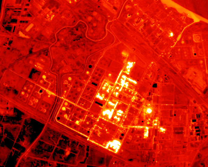
Above:
Stanlow Refinery, Ellesmere Port, UK.
Courtesy SSTL
The image clearly shows parts of the refinery that are emitting significant amounts of heat in comparison to other areas. The two black rectangles close to the centre of the image are buildings with low emissivity and heat loss in comparison to some bright areas where higher emissivity is evident. In the top right of the image, the mixing of warmer water from a side channel into the cooler river can also be clearly seen.
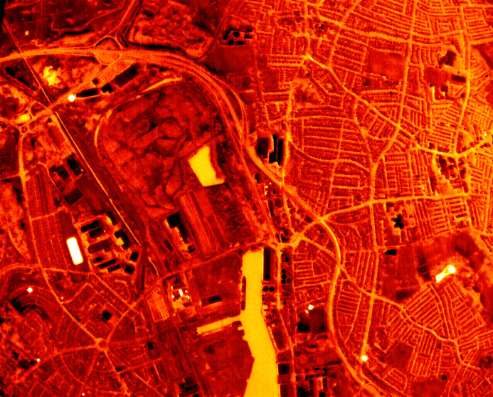
Above:
West Float Docks, Birkenhead, UK.
Courtesy SSTL
This image is centred on West Float Docks, Birkenhead where RFA Fort Austin can be clearly seen moored up in the dock. The dark objects in this image are likely to be buildings with metal roofs, which have a low emissivity. The larger bright areas are small lakes which cool more slowly than the surrounding land.
SSTL’s Carbonite Satellite Range
Satellite Vu’s MWIR satellite is based on DarkCarb, a satellite from SSTL’s Carbonite series of platforms - small, ultra low-cost, capable, platforms designed and built for rapid-delivery. The first Carbonite satellite, Carbonite-1, was launched in 2015 to demonstrate 1m GSD high resolution imagery and video within a shortened delivery schedule. Built in just 6 months it applied SSTL’s experience and design approach to exploit new, commercially developed technologies, protocols and processes, extensive use of commercial off-the-shelf (COTS) components, and SSTL’s automated production to demonstrate the use of video imagery acquired from space, opening up a whole new range of applications to the commercial space sector.
Carbonite-2, the second technology demonstrator in the Carbonite series, was launched in 2018 and introduced several design improvements and additional experiments. Data from Carbonite-2 has been supplied to the UK’s Royal Air Force to be used by the Joint Force Command National Centre for Geospatial Intelligence as an operational concept demonstration of how low cost data from small satellites can augment and enhance intelligence products used for strategic decision making, and to support operations and training by the Armed Forces.
The development of the DarkCarb imager has been supported by the UK Space Agency, via two National Space Innovation Grants and a European Space Agency (ESA) General Support Technology Programme (GSTP) grant.